New app connects you to public development information
 Last week, the City of Charlotte’s Planning, Design & Development staff released an exciting new tool called “Development Near Me.” This interactive map allows residents to see all the development in Mecklenburg County, including rezonings, grading permits, and in-review projects.
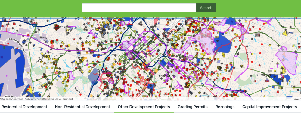
Please Note: As of October 2023, the Development Near Me tool has two new features: weekly notifications and printable reports. Users can choose to receive emails with important milestones, deadlines, and critical events for developments within a half mile of their chosen address. And users can generate comprehensive or custom reports about any project in the tool. We’re excited to see this tool grow into an even more valuable resource for the community.
How to use the Development Near Me app
Once you open the tool, you will be greeted with what looks like colorful sprinkles spilled on a map of Charlotte. Each “sprinkle,” or dot, indicates a different type of development, which can be decoded using the key provided in the tabs directly below the map.
Alternatively, you can click any dot to see a pop-up with basic information about a project, like project name, number, phase, and budget. Many of the pop-ups will have links to additional information. You can also view development within a half-mile radius of any address by typing that address into the search bar at the top of the page.
For step-by-step instructions on how to use the tool, please visit the Development Near Me webpage or watch this video.
The tool is continuously updated with the latest information, making it a fabulous way to stay current with development in your neighborhood. This is the first version, so some features, such as turning layers on and off, are not available yet. Stay tuned for updated versions in the coming months!
We are thrilled that this tool has come online so soon after the Community Benefits Task Force recommended it in 2022. Previously, development information was fragmented and difficult for residents to access. With this tool, residents can visualize what is happening in the surrounding area and across the city, noting hot spots for residential and mixed use development. You better believe we’ll be frequent users! Well done, Planning, Development & Design staff!
Have questions or feedback about the tool? Email [email protected]
And check out our Reel about the app launch!
Thanks for reading!
As a nonprofit, community support is essential for us to keep doing what we do — including providing free articles like this. If you found this article helpful, please consider supporting Sustain Charlotte.
Want to stay in the loop? Subscribe to our weekly newsletter and follow us on Instagram, Facebook, and Twitter.